Landmark: Cape Krusenstern National Monument
City: Fairbanks
Country: USA Alaska
Continent: North America
Cape Krusenstern National Monument, Fairbanks, USA Alaska, North America
Cape Krusenstern National Monument is a coastal area located in northwestern Alaska, north of the Arctic Circle.
It preserves a significant portion of the Chukchi Sea coastline and its associated cultural and natural resources.
Visual Characteristics
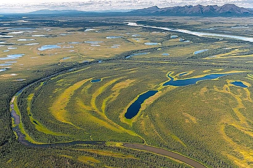
The monument consists of a long, narrow spit of land composed of gravel ridges and beaches. The terrain is generally flat with low-lying vegetation, primarily tundra grasses, sedges, and dwarf shrubs. The coastline is characterized by the Chukchi Sea to the south and west, and lagoons and wetlands to the north and east. The gravel ridges vary in height, with some reaching up to 15 meters above sea level. The water color of the Chukchi Sea is typically a muted blue or grey, depending on weather conditions.
Location & Access Logistics
Cape Krusenstern National Monument is situated approximately 50 kilometers (31 miles) northwest of Kotzebue, Alaska. Access is primarily by small aircraft or boat. There are no roads leading to the monument. Charter flights from Kotzebue are the most common method of access for visitors. Boat access is possible via the Chukchi Sea, but requires significant navigational experience due to shallow waters, ice, and unpredictable weather. There is no developed parking or public transportation within the monument itself.
Historical & Ecological Origin
The gravel ridges of Cape Krusenstern are geologically significant, representing a record of coastal progradation over thousands of years. They are formed by wave action and longshore drift, accumulating sediment along the coastline. Ecologically, the area is a critical habitat for migratory birds and marine mammals. Historically, the site has been occupied by Indigenous peoples for at least 4,000 years, with evidence of numerous archaeological sites indicating continuous use as a hunting and fishing ground.
Key Highlights & Activities
Exploration of the ancient beach ridges is a primary activity, offering insights into the area's geological history and past human occupation. Archaeological site observation is permitted, but visitors must not disturb any artifacts or features. Birdwatching is significant during migratory seasons. Limited fishing is possible in designated areas. Camping is permitted, but requires self-sufficiency and adherence to Leave No Trace principles.
Infrastructure & Amenities
There are no developed facilities within Cape Krusenstern National Monument. Visitors must be entirely self-sufficient. Restrooms, shade structures, and food vendors are not available. Cell phone signal is generally absent.
Best Time to Visit
The optimal visiting period is from late May through September, when the sea ice has typically receded and weather conditions are most favorable for travel. Mid-day offers the most consistent daylight for exploration. High tide can affect access to certain beach areas.
Facts & Legends
Cape Krusenstern is known for its extensive collection of ancient beach ridges, which have been compared to the rings of a tree, each ridge representing a period of coastal growth. Archaeological surveys have identified over 100 sites, providing a rich understanding of the region's pre-contact history.
Nearby Landmarks
- Noatak National Preserve (15km Northeast)
- Kobuk Valley National Park (40km Southeast)
- Kotzebue (50km Southwest)
- Chukchi Sea (Adjacent)