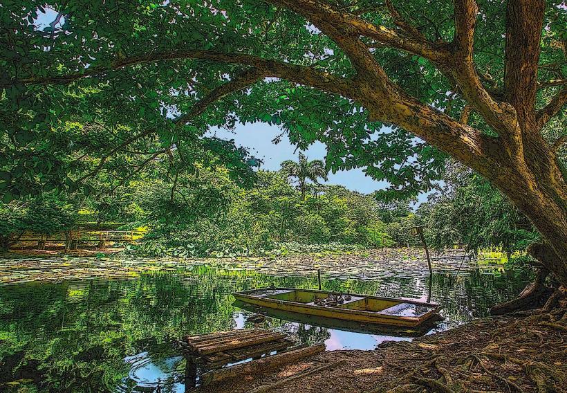
Landmark: Kernahan Lagoon
City: Mayaro
Country: Trinidad and Tobago
Continent: North America
Kernahan Lagoon, Mayaro, Trinidad and Tobago, North America
Kernahan Lagoon is a coastal body of water situated on the southeastern coast of Trinidad, near the town of Mayaro.
This estuarine environment supports a diverse range of flora and fauna, acting as a critical habitat for various bird species.
Visual Characteristics
The lagoon's water color varies from brackish brown to a deeper green depending on tidal influence and rainfall. The shoreline is characterized by mangrove vegetation, primarily red mangroves (Rhizophora mangle), with dense root systems extending into the water. Sandy deposits are present in certain areas, particularly along the seaward edge.
Location & Access Logistics
Kernahan Lagoon is located approximately 8 kilometers west of Mayaro town. Access is primarily via the Naparima-Mayaro Road (Siparia-Mayaro Road). Turn north onto Kernahan Road, a gravel track, which leads to the lagoon's edge. Parking is informal and available on the roadside. Public transport to Mayaro town is available via bus routes originating from San Fernando. From Mayaro town, local taxis or pre-arranged transport are required to reach the lagoon.
Historical & Ecological Origin
Kernahan Lagoon is a natural estuarine system formed by the interaction of freshwater runoff from inland areas and saltwater intrusion from the Atlantic Ocean. Its ecological significance lies in its role as a nursery ground for fish and crustaceans and as a vital stopover point for migratory birds. The mangrove forests are a key component of the coastal ecosystem, providing erosion control and habitat.
Key Highlights & Activities
Birdwatching is a primary activity, with opportunities to observe species such as scarlet ibis, egrets, and various shorebirds. Kayaking or small boat exploration of the lagoon's channels is possible. Fishing is permitted in designated areas, subject to local regulations.
Infrastructure & Amenities
There are no formal facilities at Kernahan Lagoon. Restrooms, food vendors, and shade structures are not present. Cell phone signal (4G/5G) is generally weak to non-existent within the immediate lagoon area.
Best Time to Visit
The best time for birdwatching is during the early morning or late afternoon when avian activity is highest. The dry season, from January to May, generally offers more stable weather conditions. Tidal patterns can influence water levels and accessibility; checking local tide charts is advisable.
Facts & Legends
Local folklore suggests that the lagoon's waters possess healing properties, a belief often associated with natural bodies of water in the region. A specific tip for visitors is to bring insect repellent, as mosquitoes can be prevalent, especially during dawn and dusk.
Nearby Landmarks
- Mayaro Beach (1.5km East)
- Nariva Swamp (7km Northwest)
- Point Radix (4km Southeast)
- Manzanilla Beach (12km North)