Landmark: Nariva Swamp
City: Mayaro
Country: Trinidad and Tobago
Continent: North America
Nariva Swamp, Mayaro, Trinidad and Tobago, North America
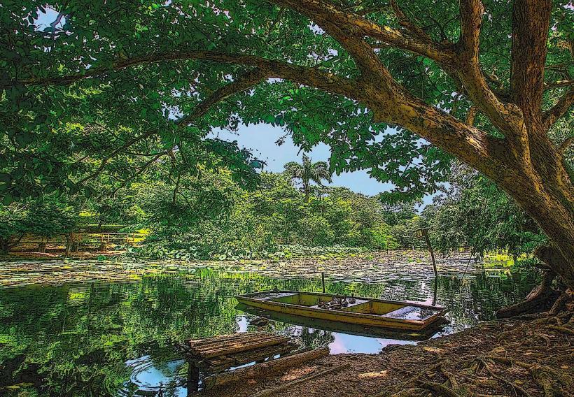
Nariva Swamp is the largest freshwater swamp in Trinidad and Tobago, located on the southeastern coast of Trinidad near the village of Manzanilla.
This extensive wetland ecosystem is characterized by a mosaic of swamp forest, palm brake, and open water bodies.
Visual Characteristics
The swamp features dense stands of moriche palms (Mauritia flexuosa) interspersed with other hardwood species. Open water areas vary in size and depth, often covered with aquatic vegetation. The water color is typically brown due to tannins leached from decaying organic matter. Mudflats are exposed during drier periods.
Location & Access Logistics
Nariva Swamp is accessible via the Manzanilla-Mayaro Road (Saddle Road). From Port of Spain, travel east on the Churchill-Roosevelt Highway, then south on the Eastern Main Road, connecting to the Manzanilla-Mayaro Road. The swamp entrance is approximately 10km south of Manzanilla village. Limited parking is available at designated access points. Boat tours are the primary method of exploration within the swamp, with operators typically departing from the southern end of the Manzanilla-Mayaro Road.
Historical & Ecological Origin
Nariva Swamp is a geologically recent formation, primarily a result of sediment deposition from the Ortoire River and coastal processes. It is classified as a freshwater swamp and estuarine environment, supporting a high level of biodiversity. Historically, the swamp has been utilized by local communities for fishing and resource gathering.
Key Highlights & Activities
Boat tours offer opportunities for wildlife observation, including various bird species, caimans, and manatees. Kayaking is possible in certain accessible channels. Birdwatching is a primary activity, particularly during migratory seasons. Guided walks on designated trails are available in some peripheral areas.
Infrastructure & Amenities
Basic amenities are limited within the swamp itself. Restrooms and food vendors are generally found in nearby villages like Manzanilla and Mayaro. Cell phone signal can be intermittent within the swamp. Shade is provided by the dense forest canopy in forested areas.
Best Time to Visit
The dry season, from January to May, offers the most accessible conditions for exploration, with lower water levels. The wet season (June to December) sees higher water levels, which can be advantageous for boat access but may limit terrestrial exploration. Early morning and late afternoon provide optimal lighting for wildlife photography.
Facts & Legends
Nariva Swamp is a critical habitat for the West Indian Manatee (Trichechus manatus), a vulnerable species. Local folklore speaks of the swamp being guarded by spirits, with tales of unusual lights and sounds attributed to these entities.
Nearby Landmarks
- Manzanilla Beach (0.5km North)
- Mayaro Beach (15km South)
- Galeota Point (12km Southeast)
- Nariva National Park (Adjacent)