Landmark: Mafeking Beach
City: Mayaro
Country: Trinidad and Tobago
Continent: North America
Mafeking Beach, Mayaro, Trinidad and Tobago, North America
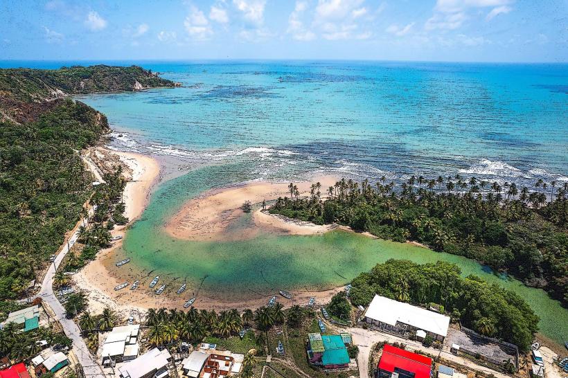
Mafeking Beach is a coastal area situated in Mayaro, on the southeastern coast of Trinidad, Trinidad and Tobago.
Visual Characteristics
The beach features a wide expanse of light brown, coarse sand. The water is typically a muted blue-green, with moderate wave action. The shoreline is bordered by a dense line of coconut palms and other tropical vegetation, creating a distinct transition from beach to forest. The beach itself is approximately 3 kilometers long.
Location & Access Logistics
Mafeking Beach is located approximately 8 kilometers east of the town of Mayaro. Access is via the Naparima-Mayaro Road (Siparia-Mayaro Road), turning north onto Mafeking Road. This road leads directly to the beach. Parking is available on unpaved areas adjacent to the beach. Public transport options are limited; local maxi-taxis operate along the Naparima-Mayaro Road, requiring a walk of approximately 1 kilometer from the main road to the beach.
Historical & Ecological Origin
Mafeking Beach is a natural formation, part of the coastal geology of Trinidad. Its formation is attributed to the deposition of sediments carried by ocean currents along the continental shelf. The adjacent vegetation is characteristic of a tropical coastal ecosystem, dominated by species adapted to saline conditions and sandy soils.
Key Highlights & Activities
Activities include swimming, sunbathing, and beachcombing. The consistent wave patterns make it suitable for bodyboarding. Fishing from the shore is also a common activity. Designated areas are suitable for picnicking.
Infrastructure & Amenities
Basic amenities include a limited number of concrete picnic tables and some shaded areas provided by natural tree cover. Restroom facilities are not consistently maintained. Cell phone signal (4G) is generally available but can be intermittent closer to the vegetation line. No food vendors are permanently stationed at the beach; visitors typically bring their own provisions.
Best Time to Visit
The best time for photography is during the late afternoon, approximately 1-2 hours before sunset, for optimal lighting conditions. The dry season, from January to May, offers the most favorable weather with lower rainfall. High tide can reduce the visible sand area.
Facts & Legends
Local folklore suggests that the beach was named after a British military outpost, though historical records do not confirm this specific connection to Mafeking, South Africa. A notable feature is the presence of leatherback turtle nesting sites during the nesting season (March to August), with specific regulations in place to protect these areas.
Nearby Landmarks
- Mayaro Beach (1.5km West)
- Manzanilla Beach (12km North)
- Nariva Swamp (8km Northwest)
- Point Radix Lighthouse (15km East)