Landmark: Bryce Canyon National Park
City: Bryce Canyon City
Country: USA Utah
Continent: North America
Bryce Canyon National Park, Bryce Canyon City, USA Utah, North America
Bryce Canyon National Park is a protected area in southern Utah, USA, known for its unique geological formations.
The park is situated adjacent to Bryce Canyon City, Utah.
Visual Characteristics
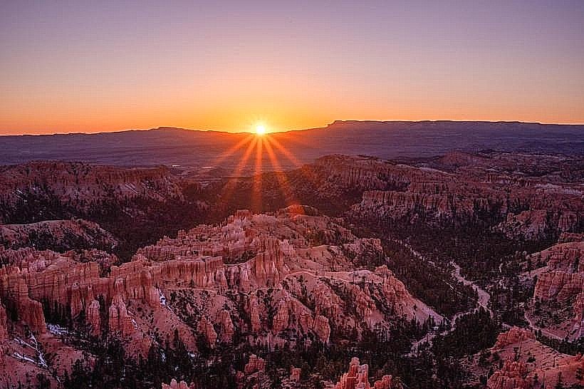
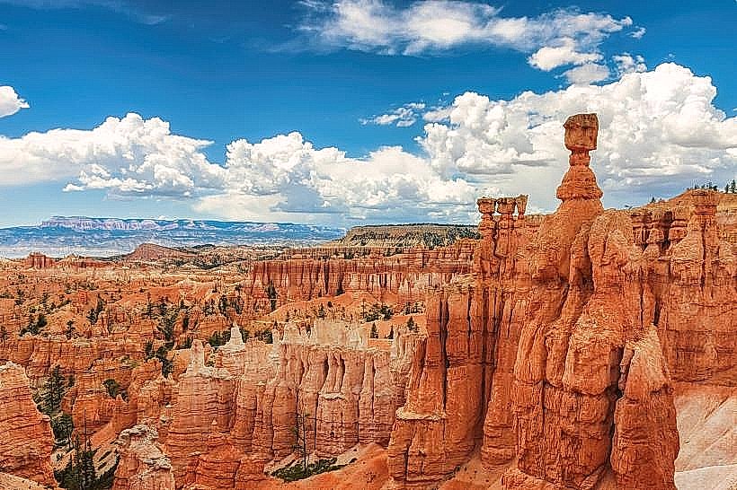
The park features a series of natural amphitheaters filled with hoodoos, which are irregular columns of rock. The dominant rock color is orange, with variations of red, pink, and white. The hoodoos range in height from a few feet to over 100 feet. The landscape is characterized by steep slopes and eroded rock formations.
Location & Access Logistics
Bryce Canyon National Park is located approximately 85 miles (137 km) east of St. George, Utah, and 260 miles (418 km) south of Salt Lake City. Access is via State Route 63 (Bryce Canyon Scenic Drive), which connects to US-89. The park entrance is directly off SR-63. Ample parking is available at the Visitor Center and various viewpoints along the scenic drive. Public transportation options are limited; shuttle services operate within the park during peak season, connecting major viewpoints and trailheads. The nearest major airport is Salt Lake City International Airport (SLC).
Historical & Ecological Origin
The hoodoos of Bryce Canyon are primarily formed by a process called frost weathering and erosion acting on sedimentary rock layers. The area was originally inhabited by Native American tribes, including the Paiute people, who left behind pictographs. The park was established as a National Monument in 1923 and designated a National Park in 1928. The geological formations are part of the Claron Formation, deposited during the Cenozoic Era.
Key Highlights & Activities
Hiking is a primary activity, with trails such as Navajo Loop Trail, Queen's Garden Trail, and Fairyland Loop Trail offering access to the hoodoos. Photography is popular, especially during sunrise and sunset when light conditions enhance the colors of the rock formations. Stargazing is also a significant draw due to the park's dark skies. Ranger-led programs are available seasonally.
Infrastructure & Amenities
Restrooms are available at the Visitor Center, Sunset Point, Sunrise Point, and Bryce Point. Shade is limited along trails but available at designated picnic areas and viewpoints. Cell phone signal is intermittent within the park, with stronger reception near the Visitor Center and developed areas. Food services are available at The Lodge at Bryce Canyon and a general store near the park entrance.
Best Time to Visit
The best time for photography is during the hour after sunrise and the hour before sunset, when the low-angle light creates strong shadows and highlights the rock colors. The months of May through September offer the most favorable weather conditions for outdoor activities. Winter visits (November through March) provide opportunities for snowshoeing and cross-country skiing, with unique visual contrasts between snow and hoodoos. High tide is not a relevant factor for this inland park.
Facts & Legends
Local Paiute legend describes the hoodoos as ancient people who were turned to stone by the trickster spirit Coyote. A specific tip for visitors is to descend into the canyon via the Navajo Loop Trail and ascend via the Queen's Garden Trail for a more gradual ascent and varied perspective of the hoodoo formations.
Nearby Landmarks
- Dixie National Forest (0.1km West)
- Grand Staircase-Escalante National Monument (15km Southeast)
- Capitol Reef National Park (70km Northeast)
- Zion National Park (80km Southwest)
- Cedar Breaks National Monument (100km West)