Landmark: Capitol Reef National Park
City: Torrey
Country: USA Utah
Continent: North America
Capitol Reef National Park, Torrey, USA Utah, North America
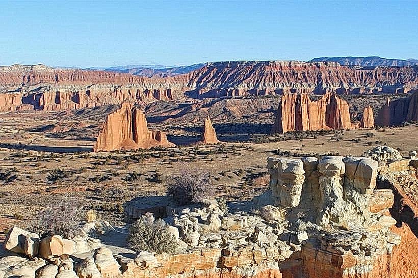
Capitol Reef National Park is a geological anticline located in south-central Utah, USA. It preserves a 100-mile long wrinkle in the Earth's crust.
Visual Characteristics
The park features a Waterpocket Fold, a nearly continuous monocline extending for 100 miles. Rock formations consist primarily of Navajo Sandstone, Wingate Sandstone, and Chinle Formation, displaying hues of red, orange, and white. The Fremont River carves through the landscape, creating canyons and alluvial plains. Vegetation includes pinyon-juniper woodlands at lower elevations and ponderosa pine forests at higher elevations. The Fruita district contains orchards established by early settlers.
Location & Access Logistics
Capitol Reef National Park is accessible via State Route 24, which bisects the park. Torrey, Utah, is located approximately 15 miles west of the park's main entrance. The nearest major airport is Salt Lake City International Airport (SLC), about a 3.5-hour drive north. Parking is available at the Visitor Center and various trailheads. No public transportation operates within the park.
Historical & Ecological Origin
The Waterpocket Fold began forming approximately 65 million years ago during the Laramide Orogeny. The Fruita district was settled in the late 19th century by Mormon pioneers who established orchards and a small community. The area was designated a National Monument in 1937 and a National Park in 1971. Ecologically, the park represents a transition zone between the Colorado Plateau and the Great Basin.
Key Highlights & Activities
Hiking trails include the Hickman Bridge Trail (1.8 miles roundtrip), Grand Wash Trail (2.2 miles one-way), and Cassidy Arch Trail (1.4 miles roundtrip). Scenic drives are available along the park's paved Scenic Drive (8 miles one-way) and the unpaved Capitol Gorge Road. Fruit picking is permitted in the historic Fruita orchards during harvest season (late August through October). Ranger-led programs are offered seasonally.
Infrastructure & Amenities
Restrooms are available at the Visitor Center, Fruita Campground, and several picnic areas. Shade structures are present at picnic sites. Cell phone signal is intermittent within the park, with limited coverage near the Fruita district. No food vendors are located within the park boundaries; services are available in Torrey and Hanksville.
Best Time to Visit
The best months for visiting are April through May and September through October, offering moderate temperatures. Summer (June-August) can be very hot, with daytime temperatures frequently exceeding 90°F (32°C). Winter (November-March) brings cold temperatures and potential snow, which can close some roads. For photography, early morning and late afternoon light provides optimal illumination of the rock formations.
Facts & Legends
The park's name originates from the Capitol Dome, a prominent white sandstone formation resembling the U.S. Capitol building, and the "reef" refers to the steep barrier of cliffs that historically presented a challenge to travelers. A local legend tells of Butch Cassidy and his gang using the remote canyons of Capitol Reef as a hideout.
Nearby Landmarks
- Grand Staircase-Escalante National Monument (10km South)
- Dixie National Forest (5km West)
- Goblin Valley State Park (40km Northeast)
- Bryce Canyon National Park (100km Southwest)
- Arches National Park (150km East)