
Landmark: Cathedral Valley
City: Torrey
Country: USA Utah
Continent: North America
Cathedral Valley, Torrey, USA Utah, North America
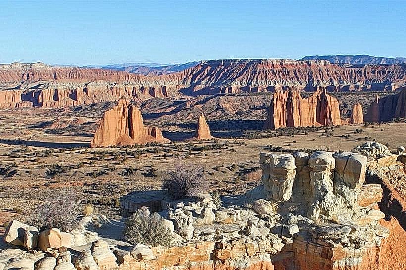
Cathedral Valley is a geological region located within Capitol Reef National Park, near Torrey, Utah. It is characterized by a landscape of eroded sandstone monoliths and colorful bentonite hills.
Visual Characteristics
The area features towering sandstone temples, also known as buttes and mesas, composed of Entrada Sandstone. These formations exhibit distinct layering and are often capped by a harder layer of Curtis Formation sandstone. The surrounding landscape includes rolling hills of dark, slick bentonite clay, which can appear deep red, brown, or grey depending on moisture content and light. Vegetation is sparse, consisting primarily of desert grasses, sagebrush, and juniper trees.
Location & Access Logistics
Cathedral Valley is accessed via the Cathedral Valley Loop Road, a 60-mile unpaved route. The primary access points are from the north end of the park, off Highway 24, approximately 35 miles east of Torrey, and from the south end, also off Highway 24, about 15 miles west of Hanksville. The loop road is generally passable for high-clearance vehicles, and four-wheel drive is recommended, especially after rain or snow. Passenger cars are not advised. The nearest major town with services is Torrey, Utah, located about 35 miles west of the northern park entrance. Parking is available at designated pull-offs along the loop road.
Historical & Ecological Origin
Cathedral Valley's formations are the result of millions of years of geological processes. The Entrada Sandstone was deposited during the Jurassic period as sand dunes. Subsequent uplift and erosion by wind and water have sculpted these sandstones into their current monumental shapes. The bentonite hills are derived from volcanic ash that settled in ancient seas, later compacting and altering into clay. The region is classified as a high desert ecosystem.
Key Highlights & Activities
Visitors can drive the Cathedral Valley Loop Road to observe the geological formations. Key points of interest include the Temples of the Sun and Moon, the Lower Cathedral, and the Upper Cathedral. Hiking is possible on informal trails to the base of some formations. Photography is a primary activity, particularly during sunrise and sunset when light conditions enhance the colors and shadows of the landscape. Stargazing is also notable due to the low light pollution.
Infrastructure & Amenities
There are no developed facilities within Cathedral Valley itself. Restrooms are not available. Shade is minimal, provided only by natural rock overhangs. Cell phone signal is generally absent throughout the loop. No food vendors are present; visitors must carry all necessary supplies, including water and food. Designated primitive campsites are available at a few locations along the loop road, requiring advance reservations.
Best Time to Visit
The best time for photography is during the golden hours of sunrise and sunset. Spring (April-May) and Fall (September-October) offer the most pleasant temperatures for exploration. Summer (June-August) can be extremely hot, with daytime temperatures frequently exceeding 100°F (38°C). Winter (November-March) can bring snow and ice, making the loop road impassable for most vehicles. The loop road's condition is highly dependent on recent weather; check with the Capitol Reef National Park visitor center for current road status before attempting the drive. There are no tide considerations.
Facts & Legends
The monoliths in Cathedral Valley are often referred to as "temples" due to their imposing, cathedral-like appearance. A specific geological feature known as the "Gypsum Sinkhole" is located in the valley, a rare example of a sinkhole formed in gypsum-rich soil.
Nearby Landmarks
- Capitol Reef National Park Visitor Center (15km Southwest)
- Fruita Historic District (20km Southwest)
- Hanksville (40km East)
- Goblin Valley State Park (60km Southeast)
- Grand Staircase-Escalante National Monument (Access points vary, approx. 70km South)


