Landmark: Umayyad Ruins of Anjar
City: Zahle
Country: Lebanon
Continent: Asia
Umayyad Ruins of Anjar, Zahle, Lebanon, Asia
The Umayyad Ruins of Anjar is a highly preserved, fortified archaeological site situated in the fertile Beqaa Valley, within the Zahle District of the Bekaa Governorate, Lebanon. It represents the only surviving example of an inland commercial city built entirely during the Umayyad Caliphate, functioning today as a protected monument and a UNESCO World Heritage site.
Visual Characteristics
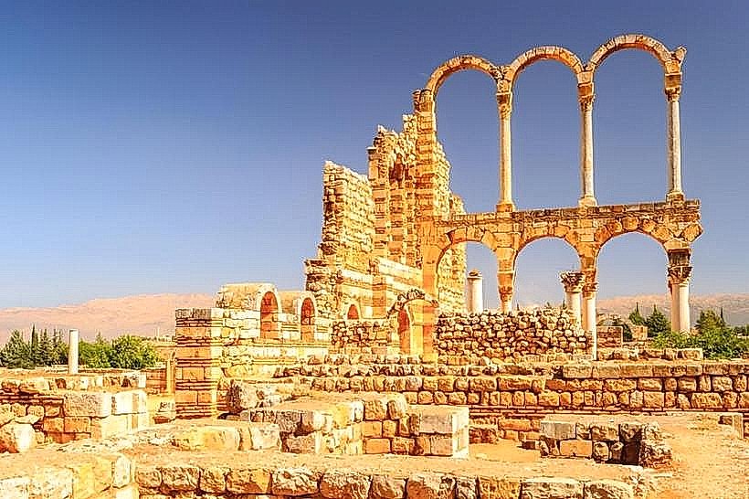
The ruins are defined by a strict orthogonal layout forming a perfect rectangle measuring 385 by 350 meters, enclosed by a massive 2-meter-thick stone wall fortified with 40 semi-circular defensive towers. The construction features a distinctive architectural layering where local cream limestone blocks alternate with bands of red baked bricks, reflecting a direct stylistic adaptation of Byzantine building techniques. The interior is divided into four equal quadrants by two primary colonnaded avenues-the Cardo Maximus and the Decumanus Maximus-which intersect at a monumental tetrapylon. The site features the standing columns of a grand palace, a public bath complex with distinct caldarium and frigidarium chambers, and the remains of over 600 symmetrical commercial shopfronts.
Location & Access Logistics
The archaeological park is located directly on the eastern edge of the modern town of Anjar, approximately 58 kilometers east of Beirut and less than 5 kilometers from the Masnaa border crossing into Syria. Access from Beirut is via the primary international Damascus highway, crossing Mount Lebanon down into the Beqaa Valley floor, then turning south at the Chtaura junction toward Anjar. A large, paved public parking lot is situated directly in front of the main northern entry pavilion. Public transport options include intercity minivans departing from the Al-Cola or Charles Helou transport hubs in Beirut to Chtaura, from which local shared taxis must be taken to complete the final 15 kilometers to the site entrance.
Historical & Ecological Origin
The city was founded and constructed between 705 and 715 CE under the patronage of Caliph Al-Walid I, who commissioned the project to establish a strategic commercial and military outpost at the intersection of the primary trade routes connecting Damascus, Homs, Baalbek, and the Mediterranean coast. Geologically, the site sits on a flat alluvial plain formed by centuries of sediment accumulation from the surrounding Anti-Lebanon and Mount Lebanon mountain ranges. The city was systematically dismantled and abandoned after 744 CE following the defeat of Caliph Ibrahim by Marwan II, leaving the structural foundations buried under agricultural silt until systematic excavations commenced in 1949.
Key Highlights & Activities
Primary activities focus on self-guided pedestrian exploration along the wide, paved Roman-style avenues. Visitors can observe the architectural engineering of the Grand Palace, where multiple tiers of slender marble columns support preserved stone arches. Landmark features include the reconstructed tetrapylon structure at the central crossroads and the intricate brickwork detailing within the ancient thermal baths. The site is open for historical and architectural photography, with clear paths providing unhindered access to the outer defensive ramparts.
Infrastructure & Amenities
The entrance complex is equipped with a formal ticket validation counter, a visitor documentation kiosk, and modern public restroom facilities. Shade is heavily limited across the large, open-air archaeological zone, though mature cypress and eucalyptus trees planted along the perimeter pathways provide intermittent cover. Cellular network coverage (4G) is stable and continuous across the entire valley floor. No commercial food or beverage vendors operate inside the historic walls, but numerous traditional Armenian restaurants, local bakeries, and markets are positioned within a 200-meter walk along the adjacent town roads.
Best Time to Visit
The optimal hours for architectural photography are during the early morning (08:00 to 10:00) or late afternoon (16:00 to 18:00), when low-angle sunlight strikes the limestone columns and highlights the contrasting red brick bands against the sky. The ideal months for visiting are from April to June and September to November, avoiding the intense dry heat of the mid-summer valley climate and the heavy winter rains or occasional snowfall that can obstruct pedestrian routes between December and March.
Facts & Legends
A verified engineering attribute of the Umayyad Ruins of Anjar is its advanced, comprehensive subterranean sanitation network; the entire city was built over a series of vaulted stone sewer channels fitted with regular inspection grates, allowing rainwater and waste from the public baths and private residences to flush directly out into the local agricultural plain. Local historical records highlight that during the 1949 excavations, archaeologists discovered that the Umayyad builders did not quarry new materials for the entire city, but instead systematically salvaged columns, capitals, and stone blocks from the nearby ruins of classical Roman and Byzantine structures across the Beqaa Valley.
Nearby Landmarks
Anjar Spring (Nabaa Anjar): 1.8km Northeast
Kfoury Winery: 3.5km Northwest
Chateau Rayak Vineyard: 4.8km North
Majdel Anjar Roman Temple Ruins: 3.2km South