Landmark: Mount Jali
City: Kigali
Country: Rwanda
Continent: Africa
Mount Jali, Kigali, Rwanda, Africa
Mount Jali is the highest point in the city of Kigali, rising to an elevation of approximately 2,071 meters above sea level. It is situated in the Gasabo District, directly north of Mount Kigali, and dominates the northern skyline of the capital.
Visual Characteristics
The mountain is a prominent ridge characterized by steep, emerald-green slopes and a series of rugged metamorphic rock outcrops. Its vegetation consists primarily of dense eucalyptus and pine forests, interspersed with small-scale terraced farms on the lower reaches. The summit is marked by a cluster of large white telecommunication towers and satellite dishes, which are visible from most parts of the city. The ridgeline offers a sharp contrast between the urban expansion of the valley floor and the sparsely populated highland terrain.
Location & Access Logistics
Mount Jali is located roughly 7km north of the Kigali City Tower. The primary access route is via the paved Kigali–Musanze Road (RN1) to the Giticyinyoni area, from which an unpaved, winding mountain road ascends to the summit. While 4x4 vehicles can reach the top, the ascent is a popular hiking route starting from the Nyabugogo or Gatsata neighborhoods. Public transport "matatus" serve the base of the mountain at the Giticyinyoni junction; from there, visitors typically use motorcycle taxis (motos) for the initial climb or proceed on foot.
Historical & Ecological Origin
Geologically, Mount Jali is part of the Mesoproterozoic Rwanda-Burundi belt, composed largely of resistant quartzite and schist. It has historically served as a critical strategic site for telecommunications and military observation due to its height. The mountain acts as a primary watershed for the city, with its western runoff flowing into the Nyabarongo River system. Unlike the more developed Mount Kigali, Jali retains a higher density of indigenous bird life and unfragmented forest patches.
Key Highlights & Activities
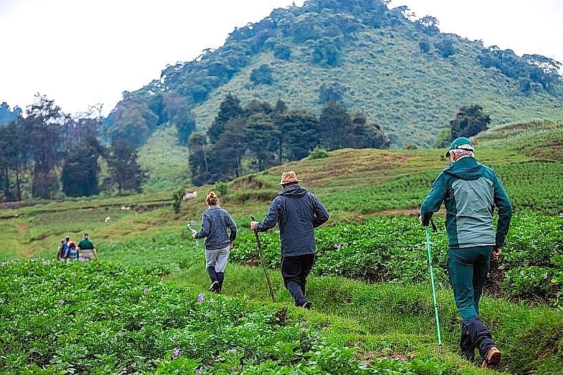
Hiking the main ridge trail is the primary activity, offering 360-degree views of the Kigali metropolitan area to the south and the rural valleys of the Northern Province to the north. Mountain biking is common on the steep, technical service roads. The peak is a major site for paragliding launches when wind conditions are favorable. Bird watching is productive in the forested upper zones, where species like the cinnamon-chested bee-eater are frequently sighted.
Infrastructure & Amenities
Infrastructure at the summit is limited to telecommunication utility buildings and a small military outpost. There are no formal restrooms, food vendors, or visitor centers on the mountain; hikers must be self-sufficient with water and supplies. Cell phone signal is exceptionally strong (5G) due to the proximity of the transmission towers. Shaded areas are abundant under the forest canopy along the trails, though the summit itself is exposed.
Best Time to Visit
The optimal period for hiking is during the long dry season from June to August, when visibility is at its maximum and the mountain trails are not slippery. For photography, the early morning (06:30 to 08:30) is recommended to capture the city emerging from the valley mist. Late afternoon visits provide the best lighting for the southern face of the mountain, though hikers should plan to descend before the rapid equatorial sunset at 18:00.
Facts & Legends
Local residents often refer to Mount Jali as the "Ear of Kigali" because it houses the majority of the city's radio and television broadcast infrastructure. A verified historical oddity is that during the rainy season, the peak is frequently shrouded in "dry mist" (locally known as igihu), which can reduce visibility to less than 10 meters, even while the city center below remains clear.
Nearby Landmarks
Nyabugogo International Bus Terminal – 3.1km South
Kigali Independent University (ULK) – 3.8km Southeast
Kigali Genocide Memorial – 4.5km Southeast
Nyabarongo River Bridge – 2.8km West
Gatsata Commercial Zone – 2.5km East