Landmark: Newspaper Rock
City: Monticello
Country: USA Utah
Continent: North America
Newspaper Rock, Monticello, USA Utah, North America
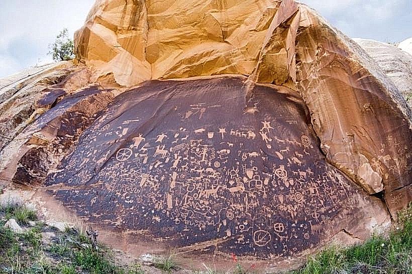
Newspaper Rock is a prominent sandstone monolith located in San Juan County, Utah, near Monticello.
It is recognized for its extensive collection of petroglyphs, representing a significant historical record of ancestral Puebloan and Ute peoples.
Visual Characteristics
The landmark is a free-standing sandstone spire, approximately 20 meters (65 feet) in height. Its surface is heavily marked with petroglyphs, etched into the dark desert varnish that coats the rock. The surrounding terrain is arid desert, characterized by sparse vegetation and exposed rock formations.
Location & Access Logistics
Newspaper Rock State Historical Monument is situated 21 miles (34 km) northwest of Monticello, Utah. Access is via State Route 191 North, then turning west onto County Road 10. The final approach is on a well-maintained dirt road. Parking is available at the base of the rock. No public transport services this location.
Historical & Ecological Origin
The petroglyphs on Newspaper Rock are estimated to have been created over a period of at least 2,000 years, with the oldest dating back to approximately 200 BCE. The rock itself is composed of Navajo Sandstone, a geological formation common in the Colorado Plateau, shaped by wind erosion over millennia.
Key Highlights & Activities
Observation of petroglyphs is the primary activity. Visitors can walk around the base of the rock to view the etchings. Interpretive signage provides context for the various symbols and their potential meanings. Photography is permitted.
Infrastructure & Amenities
A small parking area is present. There are no restrooms or food vendors at the site. Cell phone signal is unreliable. Limited shade is available from the rock itself during certain times of day.
Best Time to Visit
For optimal viewing of the petroglyphs, early morning or late afternoon light provides the best contrast and definition. The months of April, May, September, and October offer the most temperate weather conditions, avoiding the extreme heat of summer and the potential for winter snow.
Facts & Legends
The sheer density and variety of petroglyphs on Newspaper Rock have led to its designation as a historical monument. While no specific legends are widely documented, the site is considered sacred by some Native American tribes. A unique aspect is the layering of different artistic styles and symbols from various cultural periods, offering a visual timeline.
Nearby Landmarks
- Newspaper Rock State Historical Monument (0km)
- Indian Creek State Park (15km Southwest)
- Bears Ears National Monument (Access points vary, approximately 30km West)
- Manti-La Sal National Forest (Southern boundary approximately 25km North)
- Valley of the Gods (40km Southwest)