Landmark: Triumphal Arch of Tyre
City: Tyre
Country: Lebanon
Continent: Asia
Triumphal Arch of Tyre, Tyre, Lebanon, Asia
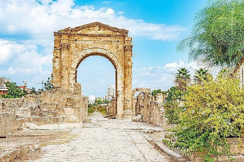
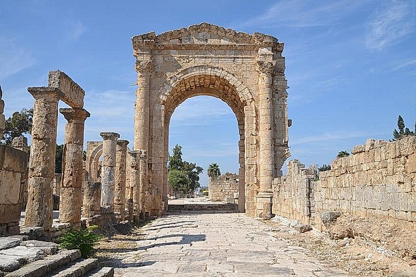
The Triumphal Arch of Tyre is a monumental Roman gateway situated within the Al-Bass Archaeological Site in Tyre (Sour), Lebanon. It stands as the architectural portal spanning the ancient imperial highway that connected the inland regions of the Levant to the maritime peninsula city.
Visual Characteristics
The monument is a massive limestone structure featuring a grand central arch flanked by two smaller lateral bays, though only the central arch has been fully reconstructed. Constructed from regional cream-colored limestone blocks, the arch rises to a height of over 11 meters. The structure exhibits classical Roman design proportions, adorned with detailed decorative cornices, stone moldings, and recessed niches that originally held imperial statues. It stands directly over a historic avenue paved with large, dark basalt stones that retain distinct grooves from ancient chariot wheels.
Location & Access Logistics
The arch is located within the western sector of the Al-Bass Archaeological Site off Al-Bass Boulevard, approximately 80 kilometers south of Beirut. Access from Beirut is via the South Coastal Highway, traveling past Sidon directly into the primary eastern entryway of Tyre. Visitors must park at the designated municipal parking lot situated at the main archaeological park ticket office. Public transportation options include coastal buses and shared minivans departing from Beirut’s Cola intersection, dropping passengers at the central Tyre Al-Bass terminal, located within a 5-minute walk of the site entrance.
Historical & Ecological Origin
The monument was constructed during the 2nd century AD, during the reign of Roman Emperor Hadrian or Antoninus Pius, to serve as a ceremonial entrance celebrating the city's imperial status. It was engineered over a flat sandy isthmus formed by the accumulation of marine sediments against the historic land bridge constructed by Alexander the Great in 332 BC. The structure collapsed due to a catastrophic regional earthquake in the 6th century AD and remained buried under soil and sand accumulation until systematic archaeological excavations fully uncovered and reassembled it in the mid-20th century.
Key Highlights & Activities
Walking underneath the central limestone arch to examine the structural vaulting and masonry alignment.
Photographing the longitudinal perspective of the basalt-paved Roman road extending through the gateway toward the city center.
Examining the iron-rimmed chariot wheel ruts cut directly into the dark paving stones beneath the monument.
Observing the adjacent remnants of the Roman aqueduct system that runs parallel to the processional avenue.
Infrastructure & Amenities
The arch is positioned within the managed archaeological park boundaries, with central public restrooms and a visitor reception center available at the main park entrance. The open-air avenue features no natural tree canopy or artificial shade structures, requiring complete sun protection during daytime visits. Mobile cellular reception is stable across the entire site, with 4G and 5G network coverage maintained by local operators Alfa and Touch. Convenience stores, bakeries, and local dining options are situated outside the gate along Al-Bass Boulevard.
Best Time to Visit
The ideal months to visit are from April to June and September to November to avoid intense summer coastal humidity and heavy winter rainstorms. The archaeological site opens daily from 8:30 AM until sunset. The optimal time of day for photography is late afternoon during the golden hour, when the setting sun directly illuminates the eastern facade of the limestone arch, creating high-contrast lighting through the central bay.
Facts & Legends
A verified historical oddity is that the arch was intentionally built at a slight angle relative to the straight axis of the highway to align precisely with the astronomical position of the sun during specific imperial festival days. Local folklore long claimed that the monumental gateway was constructed using magical architecture, as the local population believed the massive stone blocks forming the upper vault could not have been lifted and suspended without the intervention of supernatural forces.
Nearby Landmarks
Al-Bass Archaeological Site: 0.05km East
Tyre Hippodrome: 0.15km East
Tyre Aqueduct Remnants: 0.2km North
Tyre Al-Mina Archaeological Site: 1.85km West
Tyre Crusader Cathedral Ruins: 1.95km West