Landmark: Mseilha Fort
City: Batroun
Country: Lebanon
Continent: Asia
Mseilha Fort, Batroun, Lebanon, Asia
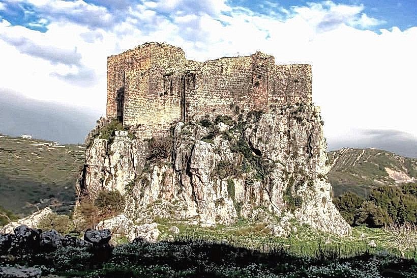
The Mseilha Fort is a historic military fortification situated north of the village of Hamat in the Batroun District of the North Lebanon Governorate. It stands on a solitary, steep-sided rock formation in the valley of the Nahr el-Jawz river, historically serving to guard the primary transit route between the cities of Tripoli and Beirut.
Visual Characteristics
The fort features a defensive design constructed from local limestone blocks, which are structurally fused to the underlying monolithic limestone bedrock. The walls follow the irregular, elongated contours of the natural rock, creating a multi-level military layout with a total thickness ranging from 1.5 to 2 meters. The architecture includes narrow vertical embrasures (loopholes) for archery and musketry, small vaulted interior residential rooms, a central courtyard, and an elevated watchtower that commands a complete view of the surrounding river gorge.
Location & Access Logistics
The fortification is positioned approximately 65 kilometers north of Beirut and 5 kilometers northeast of the coastal city of Batroun. It is directly visible from the main Beirut-Tripoli highway, with a dedicated exit lane providing access to the adjacent Mseilha Dam and historical park area. Visitors can park in the paved municipal lot at the base of the valley. Access to the fort entrance requires a brief walk across a restored stone pedestrian bridge and up a series of rock-cut steps winding around the southern face of the cliff.
Historical & Ecological Origin
The fort was constructed in its present form during the early 17th century, around 1624 CE, by Emir Fakhreddine II to secure the mountain pass after a series of regional security threats. The site itself rests on a limestone karst spur formed through millions of years of water erosion by the adjacent Nahr el-Jawz river. Archaeological surveys indicate that the 17th-century masonry likely incorporated the foundations of earlier medieval or Roman-era watchposts that previously monitored the same strategic geographical chokepoint.
Key Highlights & Activities
Primary activities include walking the internal stone staircases, exploring the vaulted lower storage chambers, and accessing the open-air roof terrace for panoramic views of the river valley and the modern reservoir. Visitors can also inspect the architectural joinery where the masonry blends into the natural cliffside. The surrounding green space is utilized for hiking along the riverbanks and crossing the historic arched stone bridge located at the foot of the hill.
Infrastructure & Amenities
The surrounding Mseilha historical park complex contains paved pedestrian trails, basic outdoor seating, and public restroom facilities located near the main parking area. There is no independent ticketing office inside the fort itself, and interior illumination relies heavily on natural light entering via the arrow slits. Cellular network coverage (4G) is functional across major national networks throughout the valley floor. Small food stalls and juice vendors occasionally operate near the parking infrastructure, with full dining options available 5 kilometers away in central Batroun.
Best Time to Visit
The optimal hours for architectural photography are during the early morning or late afternoon when low-angle sunlight strikes the vertical limestone faces, accentuating the seam between the bedrock and the man-made walls. The months from April to November offer stable dry weather conditions. The spring season (April and May) is particularly favorable, as the surrounding valley vegetation is dense and the seasonal water volume in the Nahr el-Jawz river is at its peak due to mountain snowmelt.
Facts & Legends
A verified historical detail is that the image of the Mseilha Fort was prominently featured on the old Lebanese 25-livres (pound) banknote, establishing the structure as a major architectural symbol of national heritage during the mid-20th century. Local military lore notes that the fort's internal cistern system was engineered to collect rainwater from the upper roof terraces through hidden terracotta pipes, allowing a small defensive garrison to withstand an extended siege without relying on direct access to the river below.
Nearby Landmarks
Mseilha Dam and Reservoir: 0.2km East
Monastery of Saint John the Baptist (Deir Mar Yohanna al-Qalaat): 1.2km Northeast
Smar Jbeil Citadel: 3.8km Southwest
Phoenician Sea Wall (Batroun Coast): 5.2km West
Old Souks of Batroun: 5.4km West